TIGER Roads Time Series
The TIGER (Topologically Integrated Geographic Encoding and Referencing) Roads time series dataset provides a comprehensive collection of United States road networks from 2009 to 2025, representing one of the most important foundational geospatial datasets in the digital mapping ecosystem. Developed and maintained by the U.S. Census Bureau, this dataset forms the backbone of countless mapping applications, navigation systems, and geospatial analyses across the United States.
TIGER Roads represents the most comprehensive, authoritative, and publicly available road network dataset for the United States. Each annual release contains millions of road segment features covering all 50 states, the District of Columbia, Puerto Rico, and U.S. Island Areas. The dataset's topological structure ensures that every road segment is properly connected to the broader network, enabling sophisticated routing and network analysis applications.
The time series reveals the ongoing evolution and refinement of this critical dataset. The data shows a story of quality improvement and methodological enhancement, with feature counts stabilizing around 20 million from 2010-2012, then gradually declining to approximately 16.4 million in 2025 as the Census Bureau consolidates redundant features and improves data topology.
Note: The 2009 dataset shows an anomalously high feature count (89.5 million) compared to all subsequent years. Users should verify this count and investigate potential data quality issues, duplicate features, or methodological differences in the 2009 release before using it for analysis.
Feature Count Evolution
| Year | Number of Road Features | Change from Previous Year |
|---|---|---|
| 2009 | 89,503,682 | - |
| 2010 | 20,279,763 | -69,223,919 |
| 2011 | 20,186,771 | -92,992 |
| 2012 | 19,889,811 | -296,960 |
| 2013 | 19,655,632 | -234,179 |
| 2014 | 19,609,146 | -46,486 |
| 2015 | 19,531,817 | -77,329 |
| 2016 | 19,401,722 | -130,095 |
| 2017 | 18,800,412 | -601,310 |
| 2018 | 18,315,773 | -484,639 |
| 2019 | 18,123,446 | -192,327 |
| 2020 | 18,009,370 | -114,076 |
| 2021 | 18,004,254 | -5,116 |
| 2022 | 17,979,848 | -24,406 |
| 2023 | 17,900,582 | -79,266 |
| 2024 | 17,813,006 | -87,576 |
| 2025 | 16,438,449 | -1,374,557 |
Total Change (2009-2025): -73,065,233 features (-81.6%) Total Change (2010-2025): -3,841,314 features (-18.9%)
The declining feature count from 2010 onward reflects ongoing data quality improvements through conflation processes, where redundant or duplicate road segments are merged, topology is corrected, and the overall dataset structure is refined.
Technical Specifications
Feature Properties
Each road segment contains detailed attribute information that enables sophisticated address matching and routing operations:
| Property | Description | Example Value |
|---|---|---|
| FULLNAME | Complete concatenated road name with all components | "I- 395" |
| LINEARID | Unique linear feature identifier used across TIGER products | "1104469410451" |
| MTFCC | MAF/TIGER Feature Class Code indicating road functional classification | "S1100" |
| NAME | Base street name or route number without directionals or types | "395" |
| PREDIR | Prefix directional (North, South, East, West) | null |
| PREQUAL | Prefix qualifier (Old, New, etc.) | null |
| PRETYP | Prefix type (State Route, County Road, etc.) | "344" |
| RTTYP | Route type classification for numbered highway systems | "I" |
| SUFDIR | Suffix directional (North, South, East, West) | null |
| SUFQUAL | Suffix qualifier | null |
| SUFTYP | Suffix type (Street, Avenue, Road, etc.) | null |
Route Type (RTTYP) Classifications
The route type code (RTTYP) describes the type of road for numbered highway systems:
| Code | Description |
|---|---|
| C | County Road |
| I | Interstate Highway |
| M | Common Name |
| O | Other |
| S | State Recognized Highway |
| U | U.S. Highway |
MTFCC Road Classifications
| Code | Description | Typical Use |
|---|---|---|
| S1100 | Primary Road | Interstate highways, major arterials |
| S1200 | Secondary Road | State highways, major collectors |
| S1400 | Local Neighborhood Road | Residential streets, local roads |
| S1500 | Vehicular Trail | Unpaved roads, 4WD trails |
Earth Engine Assets
The complete time series is available in Google Earth Engine under the following asset structure:
Where [YEAR] ranges from 2009 to 2025.
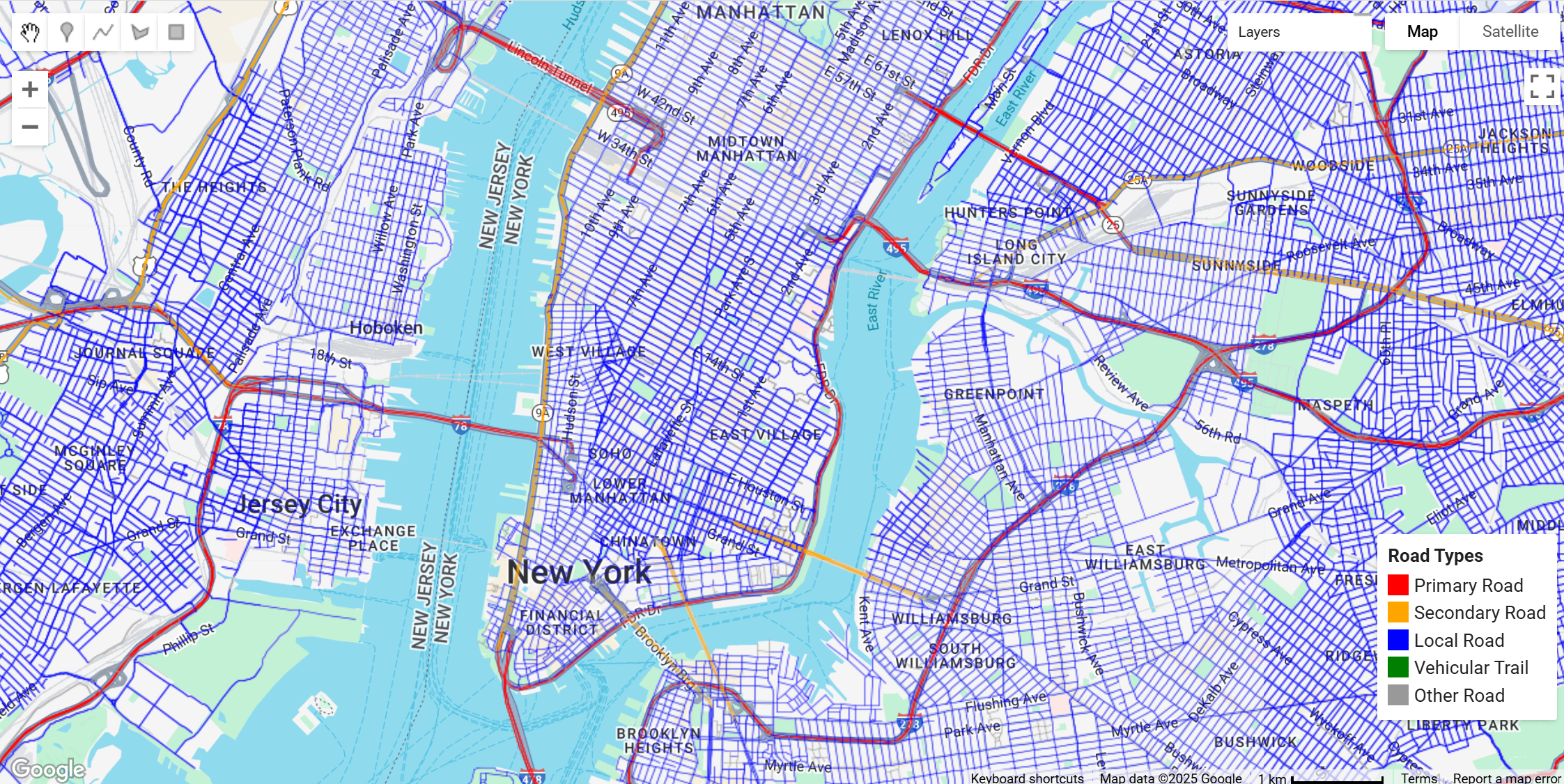
Earth Engine Snippet
// Load and visualize TIGER Roads for a specific year
var year = 2025;
var roads = ee.FeatureCollection("projects/sat-io/open-datasets/TIGER/" + year + "/Roads");

// Style roads with basic blue color
var styled = roads.style({color: '#4285F4', width: 1});

// Center map on New York City
Map.setCenter(-73.99172, 40.74101, 12);
Map.addLayer(styled, {}, 'TIGER/' + year + '/Roads');
Citation
U.S. Census Bureau. TIGER/Line Shapefiles [Year]. Washington, DC: U.S. Census Bureau.
Available at: https://www.census.gov/geographies/mapping-files/time-series/geo/tiger-line-file.html
License
The U.S. Census Bureau offers some of its public data in machine-readable format via an Application Programming Interface (API). All of the content, documentation, code and related materials made available through the API are subject to these terms and conditions
Keywords : TIGER, Roads, Transportation, Infrastructure, Time Series, U.S. Census Bureau, Network Analysis, Routing, Navigation, GIS, Temporal Analysis, National Mapping
Created by: U.S. Census Bureau
Curated for GEE by: Noah Weidig, Victoria Donovan and Samapriya Roy
Last Updated: 2025-12-14
Changelog
- Added 2009-2011 years
 Ask AI