CTrees Global Aboveground Biomass 100m (2000–2025)
Preprint Notice
This dataset is associated with a non-peer-reviewed preprint submitted to EarthArXiv (May 7, 2026). The methodology and results have not yet undergone formal peer review. Users are encouraged to review the preprint directly and exercise appropriate caution when citing or applying this dataset in research. This page will be updated once this has been published
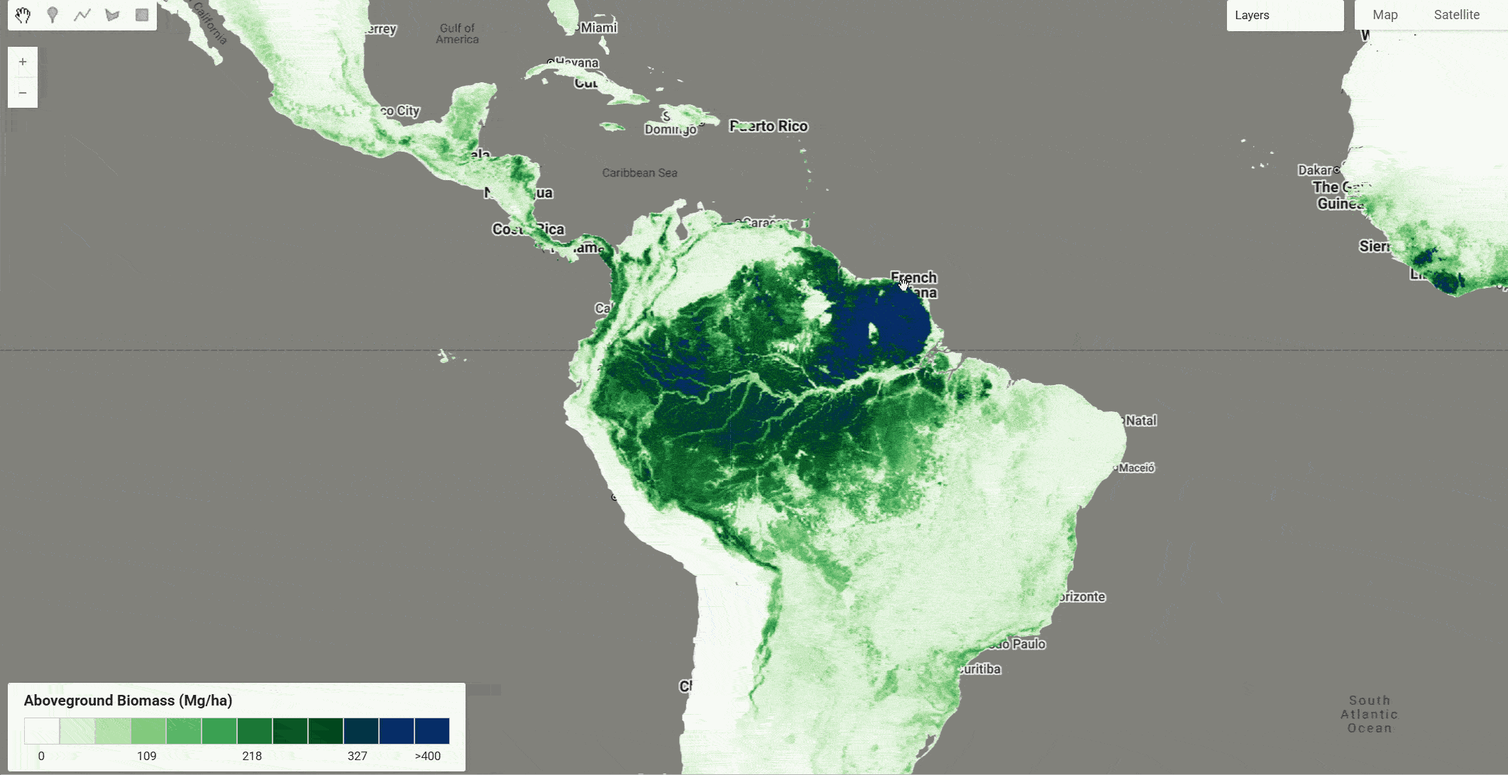
Accurate, high-resolution estimation of forest aboveground biomass (AGB) is critical for quantifying terrestrial carbon stocks and informing climate mitigation policy, yet existing global products remain constrained by coarse spatial resolution and limited temporal coverage. This dataset from CTrees presents a wall-to-wall global AGB product at 100 m native spatial resolution spanning 2000–2025, trained with a DenseNet deep learning architecture using independent AGB reference labels from ALS-derived AGB, field-plot and forest-inventory samples from the research community, selected regional and national inventories, and mangrove AGB training samples from global coastal regions. The predictor stack integrates Landsat surface reflectance time series, ALOS PALSAR-½ L-band backscatter, GEDI and ICESat-2 canopy-height metrics (used only as ancillary structural layers), and topographic data. On a held-out validation set of approximately 1.01 million pixels compiled across eco-regions, the product achieves R² = 0.741, RMSE = 59.5 Mg ha⁻¹, and bias = −4.82 Mg ha⁻¹. Further details about the dataset and underlying methodology can be found in the CTrees AGB Carbon Data Brief.
Band Description
Each annual image in the collection contains two bands. Raw pixel values are stored as signed int16 with a scale factor of 0.1; divide raw values by 10 to obtain values in Mg ha⁻¹.
| Band | Units | Scale Factor | Description |
|---|---|---|---|
| agb | Mg/ha | 0.1 | Aboveground biomass of dry matter in live woody vegetation. Generated by a cluster-aware DenseNet framework integrating Landsat optical imagery, ALOS PALSAR L-band microwave backscatter, and lidar/field reference data to translate structural height metrics into biomass density. |
| uncertainty | Mg/ha | 0.1 | Pixel-level residual uncertainty in AGB estimates. Uncertainty grows with biomass magnitude, consistent with optical and SAR saturation in dense-canopy conditions. |
Scale Factor
Raw pixel values must be divided by 10 to obtain true AGB values in Mg/ha (e.g., a raw value of 352 = 35.2 Mg/ha). For conversion to carbon (C), multiply AGB by 0.5. For conversion to CO₂ equivalent, multiply carbon by 3.667.
Image Properties
Each image carries the following metadata properties:
| Property | Value | Description |
|---|---|---|
agb_scale_factor | 0.1 | Multiply raw AGB band values by this factor |
agb_units | Mg/ha | Units after applying scale factor |
uncertainty_scale_factor | 0.1 | Multiply raw uncertainty band values by this factor |
uncertainty_units | Mg/ha | Units after applying scale factor |
carbon_conversion_factor | 0.5 | Multiply AGB by this to get carbon mass |
co2e_conversion_factor | 3.667 | Multiply carbon by this to get CO₂ equivalent |
spatial_resolution_m | 100 | Native spatial resolution in meters |
year | e.g. 2000 | Year of the annual AGB estimate |
Citation
Yang, Y., Saatchi, S., Kwon, N., Lin, W.T., Liu, Z., Li, S., DalAgnol, R., Sagang, L.B., 2026.
From Snapshot Maps to Continuous Monitoring of Global Forest Carbon at 100 m Resolution
(2000–2025). EarthArXiv (preprint). https://doi.org/10.31223/X5KJ4Q
Dataset Citation
CTrees. (2026). CTrees Global Aboveground Biomass 100m (2000–2025) [Data set].
https://doi.org/10.82924/7vmb-zv66
Earth Engine Snippet
var collection = ee.ImageCollection("projects/sat-io/open-datasets/CTREES-GLOBAL-AGB-100M");
print(collection);
print(collection.size());

// --- Rescale function: apply scale factor and mask pixels <= 0 ---
function rescaleAGB(image) {
  var scaled = image.multiply(image.getNumber('agb_scale_factor'));
  return scaled.updateMask(scaled.gt(0)).copyProperties(image, image.propertyNames());
}

// --- Temporal window ---
var startDate = '2000-01-01';
var endDate   = '2025-12-31';

var filtered = collection
  .filterDate(startDate, endDate)
  .map(rescaleAGB);

var agb = filtered.sort('system:time_start', false);

// --- Visualization parameters ---
var visParams = {
  bands: ['agb'],
  min: 0,
  max: 400,
  palette: [
    '#f7fcf5', '#d9f0d3', '#b2e0a8', '#84ca7e', '#5db96a',
    '#38a152', '#1f7f3b', '#0d5c26', '#00441b', '#023640',
    '#042864', '#08306b'
  ]
};

Map.setCenter(-62, -4, 4);
Map.addLayer(agb, visParams, 'AGB (Mg/ha)');
License & Usage
This dataset is licensed under a Creative Commons Attribution 4.0 International (CC-BY 4.0) license. You are free to copy, redistribute, and build upon the material for any purpose, including commercially, provided you give appropriate credit, provide a link to the license, and indicate if changes were made.
Provided by: Yang et al 2026
Curated in GEE by: Samapriya Roy
Keywords: Aboveground Biomass, AGB, Forest Carbon, Global, 100m, Deep Learning, DenseNet, Landsat, ALOS PALSAR, GEDI, ICESat-2, Temporal Change, REDD+, Carbon Monitoring, CTrees
Last updated: 2026-06-02
 Ask AI