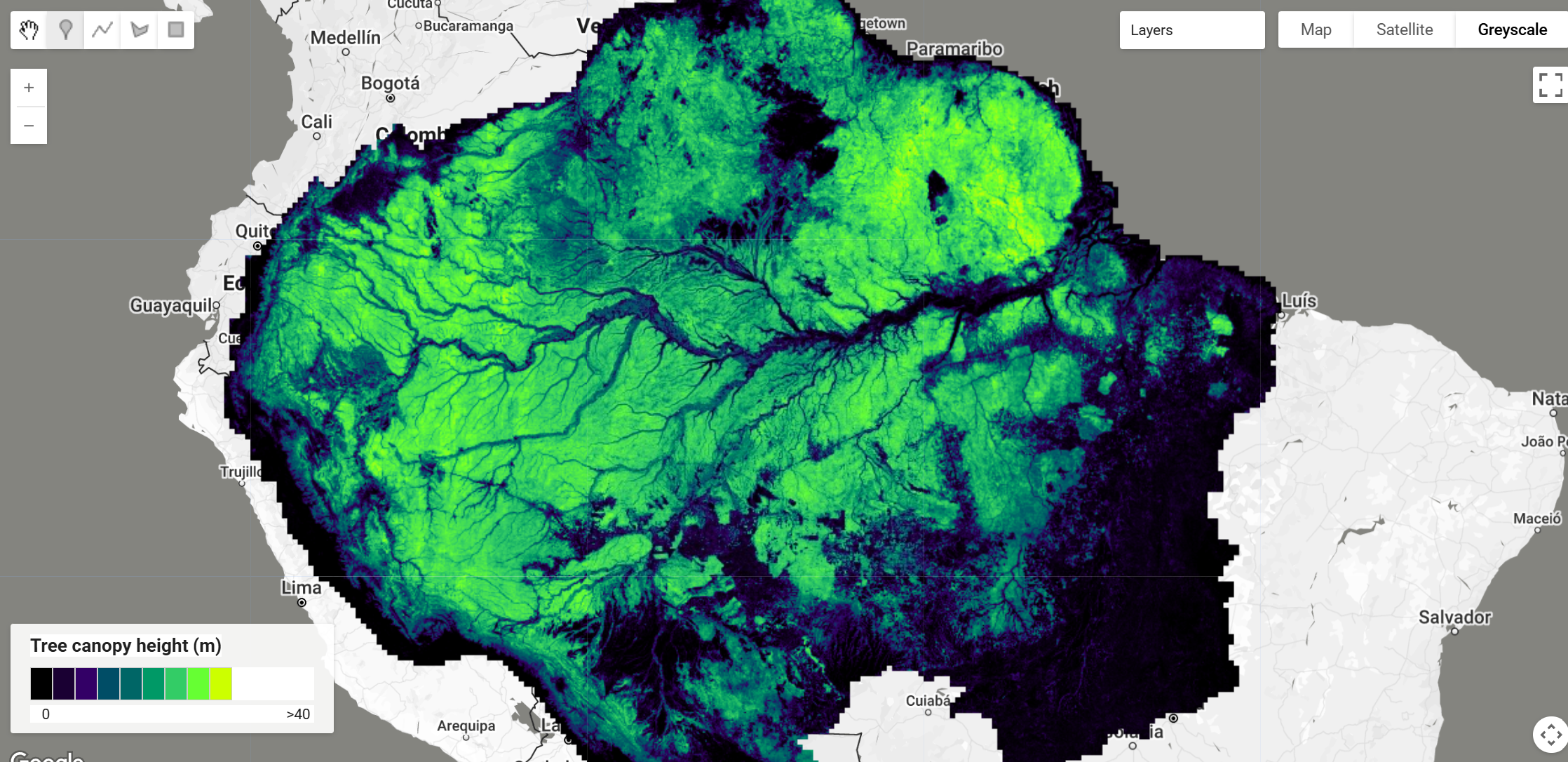
High Resolution Amazon Canopy Tree Height Dataset
This dataset provides high-resolution (~4.78 m) tree canopy height for the Amazon forest for the period 2020-2024. It was generated using a U-Net deep learning model adapted for regression, trained with Planet NICFI satellite images and informed by LiDAR-derived canopy height models (CHMs). The model predicts mean tree canopy height and has demonstrated a mean error of 3.68 m in validation samples, successfully estimating canopy heights up to 40-50 m with relatively low systematic bias. The study determined that the Amazon forest has an average canopy height of approximately 22 m. You can find additional information in the preprint
Key Features and Details
Spatial Resolution: ~4.78 meters
Temporal Coverage: Composite for 2020-2024. The model was trained using Planet NICFI images from 2015-12-01 to 2024-06-01 and LiDAR data collected between 2008 and 2018. The final Amazon forest map is a mean for the period 2020-2024.
Coverage: Amazon forest domain (approximately 8,260,920 km²)
Accuracy: Mean Absolute Error (MAE) of 3.68 m on validation samples. The model estimates heights up to 40-50 m without significant saturation.
Data Format: To obtain the actual height in meters, the pixel values in the asset must be divided by 2.5. The original CHM was multiplied by 2.5 and saved as integer 8 bits.
Mean Amazon Canopy Height: Estimated at ~22.09 m
Data Sources
Satellite Imagery: Planet NICFI (Norway's International Climate and Forest Initiative) images (Red, Green, Blue, Near-Infrared bands) at ~4.78 m spatial resolution.
Reference Data (LiDAR): - Brazilian Agricultural Research Corporation (Embrapa) - "Sustainable Landscapes Brazil" Program (2015-2018) - National Institute for Space Research (INPE, Brazil) - EBA (Biomass Estimation of the Amazon) project (2016-2018) - São Paulo City Hall (Brazil) - LiDAR dataset covering the São Paulo Metropolitan Region (2017)
Building Footprints (for masking): Google Open Buildings dataset for South America
Citation
Wagner, F.H., Dalagnol, R., Carter, G., Hirye, M.C.M., Gill, S., Takougoum, L.B.S., Favrichon, S., Keller, M., Ometto, J.P.H.B., Alves, L., Creze, C., George-Chacon, S.P., Li, S., Liu, Z., Mullissa, A., Yang, Y., Santos, E.G., Worden, S.R., Brandt, M., Ciais, P., Hagen, S.C. and Saatchi, S. (2025)
Wall-to-wall Amazon forest height mapping with planet NICFI, Aerial LiDAR, and a U-Net regression model. Remote Sens Ecol Conserv. https://doi.org/10.1002/rse2.70041
Dataset Preprocessing for Earth Engine
The datasets are distributed over 22,063 tiles which were downloaded and a mosaiced product was created for ingest. The scale can be applied in code and was added as a property to the image along with the units. As a result of the mosaic operation the tile naming convention with traceability back to the image was removed as a result of which the grid was added as a separate asset for allow traceability back to individual tiles.
Earth Engine Snippet
var amazonCanopyHeight = ee.Image("projects/sat-io/open-datasets/CTREES/AMAZON-CANOPY-TREE-HT");
var amazonCanopyHeight_tiles = ee.FeatureCollection("projects/sat-io/open-datasets/CTREES/CTREES-AMAZON-TILE-LOCATOR")
License
The underlying Planet NICFI satellite imagery is available for non-commercial purposes under specific agreements with Planet and Norway's International Climate and Forest Initiative. The LiDAR datasets used for training have their own respective licenses, generally public or available for research.
Provided by: Wagner et al 2025, ctrees.org
Curated in GEE by: Samapriya Roy
Keywords : Canopy Height, Amazon Forest, Tree Height, Remote Sensing, Deep Learning, U-Net, Planet NICFI, LiDAR, Tropical Forests, Forest Structure
Last updated in GEE: 2025-11-18
Changelog
- Updated Citation for Publication
 Ask AI